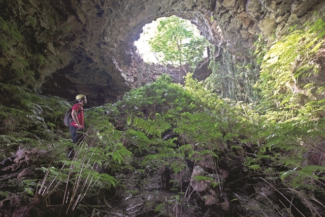
Crater C7 at the geopark. Photo:VNA
|
Located on the M’Nong plateau at average elevation of 600-700m asl, with the highest point being Ta Dung at 1,982m asl, Dak Nong Geopark - the Land of Sounds - (coordinates N12o17’48”; E107o46’58”) covers an area of c.4,760km2 of the northern districts of Dak Nong province in Vietnam’s Central Highlands, according to UNESCO.
The Geopark can be reached by several routes by land and air, including two international border gates with Cambodia. Characterised by sub-equatorial tropical monsoon and plateau climate, the area features an evenly distributed network of rivers, streams, lakes and reservoirs.
A population of c.416,000 people of 40 ethnic groups, including 3 autochthonous, live in the area, occupied mostly in agro-forestry, trade and services, and small industries.
Many archaeological, historical and cultural relics as well as scenic spots are recognised and conserved. Many festivals and traditions celebrated by ethnic cultures, in particular the UNESCO “Gong Culture Space” intangible heritage (including the man’s oldest lithophone) also contribute to the values of the Geopark.
Dak Nong Geopark is distinctive in terms of geological features and geoheritage value. Being a piece of the Gondwana ancient supercontinent, from about 200-165 Ma ago it was deeply submerged into a passive continent marginal sea, very rich in ammonite and bivalve fossils. This continental margin later, during 145-66 Ma ago became active due to plate collision, with red-bed sediments, eruptive andesite-dacite-rhyolite and intrusive gabbro-diorite-granodiorite-granite rocks. During the last 16.5 Ma, the territory became active again with wide-spread, multi-phase volcanic activities, forming a basalt cover over more than 50 percent of the Geopark area. These have been the source of some of the world’s largest and top quality bauxite deposits and a number of other minerals (sapphire, semi-precious stones etc.), and especially the fertile soils that have fed generations of local people with many industrial and fruit tree crops. In particular, young volcanic activities about tens of thousands of years ago (Late Pleistocene-Holocene) have resulted in spectacular craters, majestic waterfalls and Southeast Asia’s most extensive system of hundreds of magnificent volcanic caves, many of which have been used by prehistoric people as shelter since at least 6,000-10,000 years ago.
Following the UNESCO recognition, relevant agencies, including the Vietnam National Commission for UNESCO, the Ministry of Natural Resources and Environment and provincial authorities, along with domestic and international scientists will jointly implement plans on environmental protection, natural conservation, and rational use of resources in the park.
They aim to preserve and maximise values of geology, biodiversity, culture, history, as well as ethnic traditions of the geopark.
Dak Nong Geopark is the third UNESCO-recognised Global Geopark in Vietnam after Dong Van Karst Plateau Geopark in Ha Giang province and Non Nuoc Cao Bang Geopark in Cao Bang province, both in northern Vietnam./
VNA/VNP