Do Duc Dung, head of the Southern Institute of Water Resources Planning, told the seminar organised by Can Tho University and Utrecht University of the Netherlands to discuss groundwater planning and use and prevention of land subsidence that many studies have shown two to four centimetres of subsidence occurs in the delta each year.
“The increasing speed of land subsidence is threatening the future of the delta.”
The delta is facing challenges caused by decreasing sedimentation, illegal sand mining, riverbank and coastal erosion, and degradation of freshwater resources, he said.
It is forecast that 60 percent of the Ca Mau Peninsula would be below sea level by 2025, he said.
“To reduce land subsidence, all provinces and cities in the delta need to carefully manage the use and exploitation of groundwater.”
It is necessary to switch to plants and livestock that do not need much water, and dredge rivers and canals to increase storage of freshwater, he added.
An expert from Utrecht University said uncontrolled exploitation of groundwater could lead to greater risk of saltwater intrusion in the delta in the future.
A study found that 1.9cm to 2.8cm of land subsidence occurs in Ca Mau province every year, he said.
Ung Van Dang from the Soc Trang provincial Department of Agriculture and Rural Development said his province has 107,000 wells for daily use and irrigation.
The current groundwater exploitation in the province is estimated at 243,000cu.m per day, he said.
Since 2017 groundwater has been decreasing significantly, he said.
To address the problem, the province has tightened the issuance of licences to exploit groundwater based on scientific water resource protection measures, he said.
“It should increase the use of surface water and develop new water sources to reduce the use of groundwater.”
As long-term solutions the province is installing a network of monitoring stations, he said.
The adoption of water-efficient irrigation models and implementing action plans to improve efficiency in water use are also needed, he added.
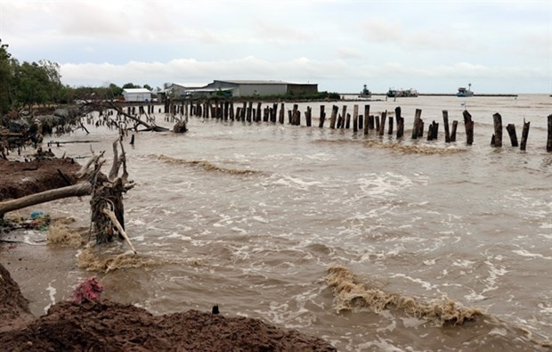
In a related development, the People’s Committee of Ca Mau province plans to relocate around 6,700 families living in erosion-prone areas along rivers and canals to safe areas by 2025.
They are mostly in coastal areas in U Minh, Tran Van Thoi, Phu Tan, Nam Can, Ngoc Hien, and Dam Doi districts.
Of them, more than 1,000 households lost their houses to erosion and are living in shelters or other people’s houses, and authorities in the southernmost province will give priority for relocating them.
Besides, more than 3,000 others live in areas facing danger or extreme danger of erosion.
More than 2,700 families live along rivers and canals that have a history of erosion or in flood-prone areas, and need to be relocated in 2020-25.
The cost of the relocation is estimated at more than 940 billion VND (40.5 million USD).
The province People’s Committee has asked the Government to prioritise allocation of funds for the task.
Ca Mau has more than 254 kilometres of coast with hundreds of estuaries.
To Quoc Nam, deputy director of its Department of Agriculture and Rural Development, said the east coast is eroding at a rate of 50 – 80 metres a month since it does not have a protective dyke.
Last month the People’s Committee said severe erosion along rivers, canals and coasts means more than 25 kilometres of coast and 1.2 kilometres of rivers and canals require urgent protective measures.
It also decided to expeditiously build embankments to prevent erosion at Rach Goc and Hoc Nang estuaries in Ngoc Hien district and Ho Gui Estuary in Nam Can and Dam Doi districts.
The province has lost nearly 9,000ha of protective forests since 2007.
VNA/VNP