From Ly Son Island, we started our journey following our predecessors. It is a beautiful island lying some 15 nautical miles from the shore, where many exhibits, relics and interesting stories of Hoang Sa Flotilla set up by the Nguyen Lords, who ruled the southern part of the country, in early 17th century to perform the tasks of exploiting marine products, measuring sea routes and protecting and planting markers of Vietnam’s sovereignty over Hoang Sa and Truong Sa archipelagoes.
Nowadays, such big family lines on Ly Son Island as Nguyen, Pham and Vo still carefully keep many important royal orders, decrees and title-conferring diplomas of the Nguyen Dynasty, having clearly prescribed the organisation, tasks and exploits of the ancient Hoang Sa Flotilla.
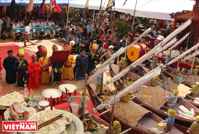
“Le khao le the linh Hoang Sa” (Feast and Commemoration Festival for Hoang Sa Soldiers) is a traditional ritual
held in the third lunar month of each year by residents of Ly Son Island
to commemorate soldiers of the Hoang Sa Flotilla. Photo: Cong Dat/VNP
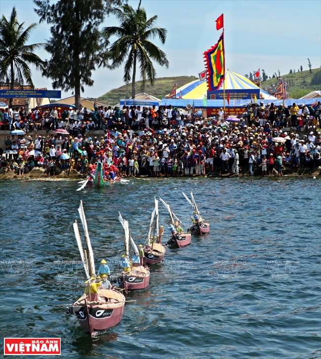
During the annual “Le khao le the linh Hoang Sa” ceremony, miniatures of fishing boats
and people are released into the sea. Photo: Cong Dat/VNP
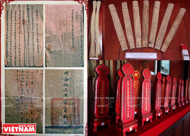
Royal orders, books and ancestral tablets related to Hoang Sa Flotilla are kept by many families. Photo: Cong Dat/VNP
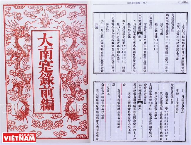 “Dai Nam Thuc luc tien bien” (The First Part of The Chronicles of Dai Nam), a historical document collection completed by Quoc Su Quan in the 4th year of Emperor Thieu Tri (1844) according to Emperor Minh Mang’s order, states that Mac Cuu, the military leader of Ha Tien, was generously awarded by Lord Nguyen Phuc Chu for conducting the measuring of Truong Sa Shoal. 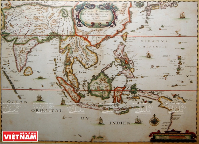 Map “Carte generale des Indes orientales et des Islles Adiacentes” made by Mariette in 1790 shows that the Paracel Islands belong to Vietnam. 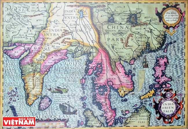 In the map “India Orientalis” made by Jodocus Hondius in 1613, Paracel and Spratly Islands are presented as connected and given the common name of Peacel. 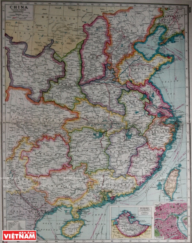 A map of China published by the Atlas of the World in London (the UK) in 1914 shows that the southernmost point of China is Hainan Island. 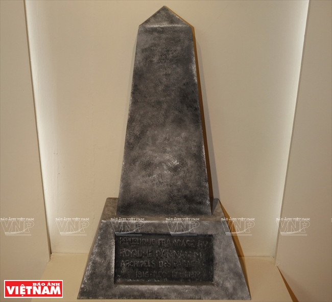 The inscription on the stele placed by the Vietnamese in June, 1938 reads: “The French Republic, The Kingdom of An Nam, The Paracel Islands, 1816 – Pattle Island – 1938”. Photo taken in 1938. Photos were taken by Tran Thanh Giang/VNP at the exhibition titled “Hoang Sa, Truong Sa - Historical Evidence” held at the Vietnam Military History Museum in 2014. |
| China started its attempt to capture Hoang Sa Archipelago from Vietnam in 1909 when Admiral Li Zhun led three gunboats to Hoang Sa area, landing on Phu Lam Island. Later in 1946, the National China administration of Chiang Kai-shek, taking advantage of the many difficulties of Vietnam after recently gaining its independence following World War II, sent troops to illegally occupy the group of islands east of Hoang Sa. In 1956, availing itself of the French withdrawal from Indochina under the Geneva Agreement and the Republic of Vietnam’s delayed take-over of a number of islands of Hoang Sa Archipelago as provided in this Agreement, China sent troops to illegally occupy An Vinh island group east of Hoang Sa Archipelago. In 1974 when Vietnam concentrated its efforts on its struggle for liberation of the south, China used force to seize and illegally occupy the entire Hoang Sa Archipelago. |
The “Chau ban” dated December 28 of the seventh reign year of King Thieu Tri (1847), submitted by Bo Cong (the Ministry in charge of construction, repair and dykes) and signed for approval by the King, clearly stated: “Hoang Sa constitutes a marine region of our country, where combat boats are sent annually to determine the sea routes”; or the “Chau ban” dated June 27 of the eleventh reign year of King Minh Mang (1830), which was submitted by the Cabinet, clearly stated the sending of boats to rescue French commercial ships that had sunk in Hoang Sa was legal.
“Dai Nam Thuc luc chinh bien” (Veritable Records of Great Vietnam), a historical book compiled by Quoc Su Quan (the authentic historical compilation office) of the Nguyen Dynasty also clearly stated: “In January of Binh Than (1836), officials of Bo Cong submitted a report saying that: Our country’s marine frontier stretches to far-away Hoang Sa, which is very important. Previously, officials were sent to draw its map, which, however, is unclear, only covering a place that is far away and large. Now men should be sent there annually to survey the entire archipelago in order to learn the sea routes there...”.
Vietnam’s sovereignty over the archipelagoes can be found in various Western documents. For instance, the investigative article “Les marchands europeénen Cochinchine et au Tonkin (1660-1695) (The European merchants in Cochinchine (southern Vietnam) and in Tonkin (northern Vietnam)) of Ch.B.Maybon published on Revue Indochinoise (Indochinese Review) in 1916 recorded the event that Duijcker, head of the Netherland Trade Office in Hoi An, complained to Lord Nguyen Phuc Lan that the commercial ship Grottebroek had sunk near Hoang Sa on July 21, 1634, then was rescued by the Vietnamese, who confiscated all their money.
The above historical and legal evidence has revealed that in the early 17th century, the Nguyen Lords’ administration in the south already mastered and controlled activities in the Hoang Sa sea. Throughout three centuries (from the 17th to 19th centuries), the Hoang Sa fleet represented the Nguyen Dynasty’s administration, constantly performing the tasks of defending Vietnam’s sovereignty over Hoang Sa and Truong Sa Archipelagoes without any disputes until the French invaded Indochina (1858) and took over these two island groups.
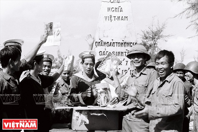 Life on Sinh Ton (Sin Cowe) Island in 1988. Photo: Vinh Quang/VNP 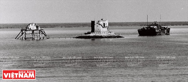 Thuyen Chai (Barque Canada Reef) in 1988. Photo: Vinh Quang/VNP 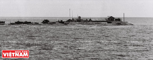 Phan Vinh (Pearson Reef) in 1988. Photo: Vinh Quang/VNP 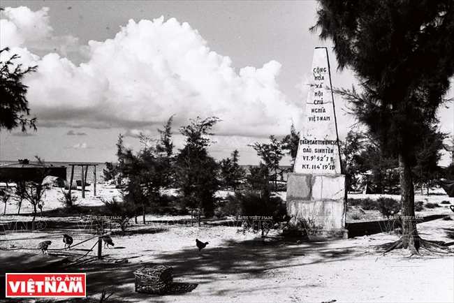 A milestone on Sinh Ton Island in 1988. Photo: Vinh Quang/VNP 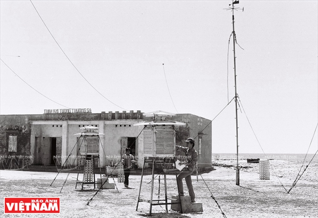 The meteorological station in Truong Sa in 1988. Photo: Vinh Quang/VNP 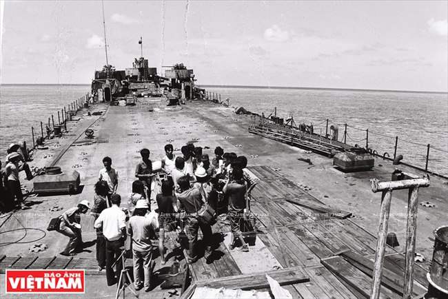 In March 1988, China used force to take over Gac Ma (Johnson South Reef) and killed 64 Vietnamese soldiers there. In April 1988, Vietnam Pictorial’s photojournalists Vinh Quang and Le Phuc went to Truong Sa Islands to report about the tension in the East Sea. In the photo: Correspondents on duty onboard HQ505 boat near Co Lin (Collins Reef). Photo: Vinh Quang/VNP |
Vietnamese history has gone through many ups and downs, but the pain of forcible and illegal occupation of Hoang Sa, the golden sand in the East Sea of our forefathers, by the Chinese still harass us today.
We strongly believe that Hoang Sa will return to the motherland, and deep in the heart of every Vietnamese, the sense of national sovereignty over the sea and islands is very sacred, which cannot be exchanged for anything as King Le Thanh Tong (the 15th century) once said, “Why should we abandon a yard of our mountains or one inch of our rivers?” (Dai Viet Su Ky Toan Thu - the Complete History of Great Vietnam).
The Breath of Truong Sa
Lying more than 350 nautical miles from Hoang Sa to the southeast is Truong Sa Archipelago of Truong Sa District of Vietnam. It occupies an important key geographical position in the business sea route across the East Sea.
Nowadays, when arriving at Truong Sa, one cannot help feeling surprised at the scenes of quiet islands like rural villages in the mainland, with green trees and fruit, cocks crowing at noon, and the pagoda bell ringing lover the sound of the waves. There have existed for many generations now the names familiar to every Vietnamese such as Truong Sa Lon (Big Truong Sa), Song Tu Dong, Song Tu Tay, Thi Tu, Nam Yet, Da Tay, Son Ca and Sinh Ton islands.
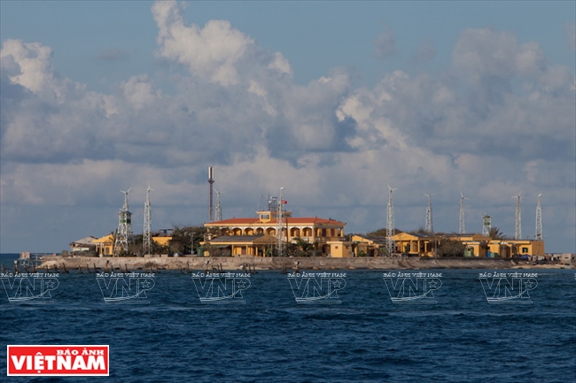 A modern wind energy system is placed on Truong Sa Dong (Central London Reef). Photo: Tran Minh Ngoc/VNP 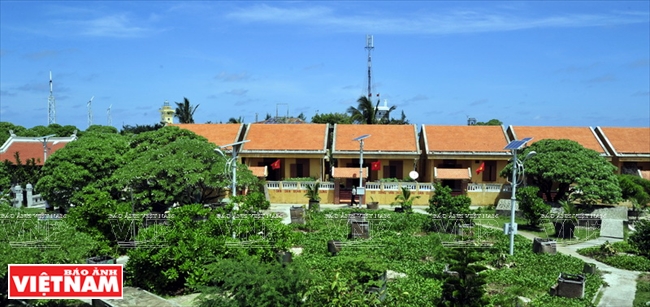 A residential area on Sinh Ton Island. Photo: Tran Minh Ngoc/VNP 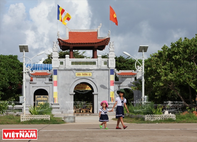 Truong Sa Lon Pagoda is a religious place that represents Vietnam sovereignty over Truong Sa Islands in the East Sea. Photo: Viet Cuong/VNP 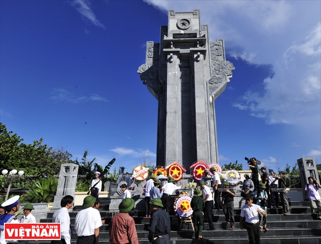 A monument for martyrs on Truong Sa Lon Island. Photo: Tran Minh Ngoc/VNP |
Thieu Van Quang, an overseas Vietnamese in the Czech Republic, was surprised when he, for the first time, set foot on Truong Sa last April: “It is truly beyond my expectation that islands in Truong Sa are so green and beautiful like townships on the mainland!”.
| Nowadays, when arriving at Truong Sa, one cannot help feeling surprised at the scenes of quiet islands like rural villages in the mainland, with green trees and fruit, cocks crowing at noon, and the pagoda bell ringing lover the sound of the waves. |
On Nam Yet Island known as “coconut land in the East Sea”, coconuts constitute not only the specialty of the island but also a source of income for islanders to widely develop the coconut planting on this island and others with a view to creating the greenery in Truong Sa Archipelago.
On Da Tay Island, the Truong Sa Marine Products One Member Limited liability Company has developed cage and raft aquaculture. In the future, the company will develop this model of raising marine products in cages on rafts to Toc Tan Island towards establishing an aquaculture and fishing hamlet in Truong Sa Archipelago, which serves as a fishing logistics base assisting fishermen in their long offshore journeys.
 “Dong dao bien dao” (A children’s song about the sea and islands) is taught during a literature class of teacher Bui Thi Nhung at Truong Sa Lon Primary School. Photo: Viet Cuong/VNP  A well-equipped clinic on Truong Sa Lon Island. Photo: Viet Cuong/VNP 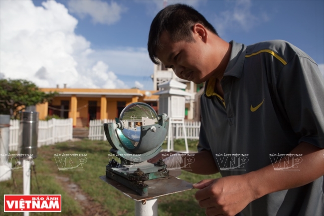 A cadre of Truong Sa Hydro-Meteorological station on duty. Photo: Viet Cuong/VNP 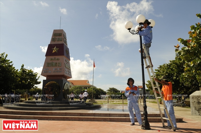 Building the infrastructure on Truong Sa Lon Island. Photo: Tran Thanh Giang/VNP 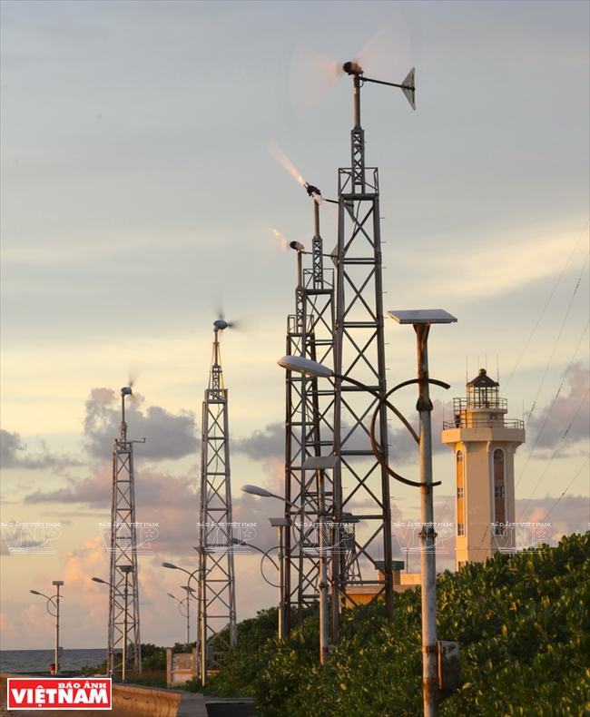 Wind turbines provide 60% of electricity used by residents on Truong Sa Lon Island. Photo: Viet Cuong/VNP  Houses on Sinh Ton Island are carefully built to resist harsh weather. Photo: Nguyen Luan/VNP 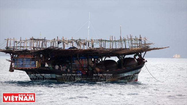 Fishermen catching fish. Photo: Viet Cuong/VNP 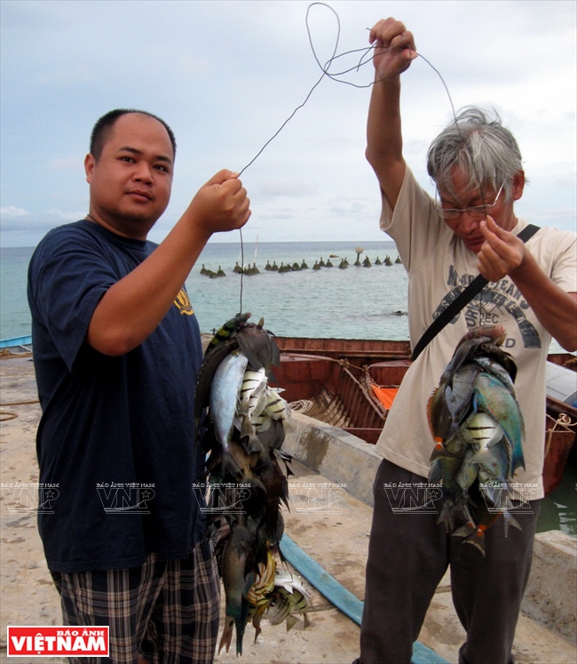 Truong Sa residents after a fishing trip. Photo: Phuong Hoa/VNA 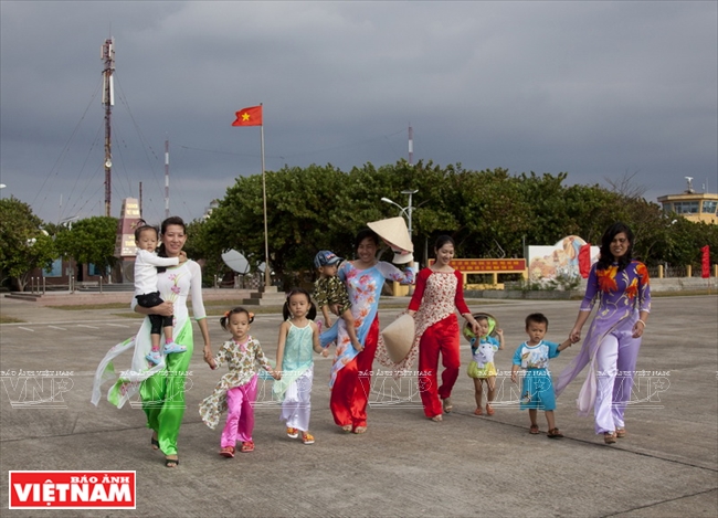 A peaceful and happy life on Truong Sa Lon Island. Photo: Dang Kim Phuong/VNP |
Along with the calmness, Truong Sa also faces the danger of potential conflicts in the face of disputes and illegal encroachments by some countries, especially aggravated regional tension created by China’s unilateral mapping of “ a nine-dash line” with a view to monopolising the entire East Sea. Its encroachment, dredging, illegal embankment and construction of many permanent facilities for military purposes in some underwater rock stretches or coral reefs in Truong Sa Archipelago has caused some serious problems.
Such deeds have not only violated the sacred territorial sovereignty of Vietnam but also seriously affected the navigation safety and security in the East Sea and destroyed the marine environment in this area.
Hua Chung confided after her recent visit to Truong Sa in April that she as well as many others cannot feel at ease when seeing with their own eyes the solid, giant, white facilities illegally built in Truong Sa as defense works by China.
The innermost feelings of Hua Chung are also the feelings of many Vietnamese when every inch of our forefathers’ land and sea is being incrementally snapped up by others. Though difficulties still lie ahead, the truth always has its reason. The Vietnamese always believe that “Hoang Sa and Truong Sa are the blood and flesh of Vietnam”.
|
After three years’ careful consideration based on Appendix II of the 1982 UN Convention on the Law of the Sea (UNCLOS), on July 12, 2016, the Permanent Court of Arbitration (PCA) in The Hague issued the ruling on the Philippines’s lawsuit against China. Under the PCA’s judgment, China has no “historic title” in the East Sea. It concluded that there was no legal basis for China to claim historic rights to resources in the areas falling within the “nine-dash line”. The PCA’s ruling also confirmed that China’s recent large-scale land reclamation and construction of artificial islands at seven places in the Spratly Islands had caused severe harm to the coral reef and violated its obligation to preserve and protect fragile ecosystems and the habitat of depleted, threatened or endangered species. |
Story: Thong Thien - Photos: Vinh Quang, Viet Cuong, Nguyen Luan,
Tran Thanh Giang, Tran Minh Ngoc, Cong Dat, Dang Kim Phuong & Phuong Hoa