Ha Giang is an old land, home to more than 20 ethnic groups who have their own traditional culture, lifestyle and customs, plus exciting festivals for visitors and researchers.
The region embraces many historical relics and landscapes, such as the Heaven Gate, the Quan Ba double mountains in Quan Ba District; the Mong King’s Vuong Palace, the Lung Cu National Flag Pole in Dong Van District; the Ma Pi Leng Pass in Meo Vac District; the Fairy Fall, the Windy Pass and the Nam Dan ancient stone ground in Xin Man District and the Quang Ngan mineral spring in Vi Xuyen District. They attract many visitors to come for fun or for research.
In 2010, the Dong Van Karst Plateau in Dong Van District was officially recognised by UNESCO as a global karst geo-park, the first of its kind in Vietnam and the second in Southeast Asia (after the Langkawi Park in Malaysia).
In 2012, the terraced rice fields in Hoang Su Phi District were listed among Vietnam’s national relics, and later in 2015 it became a national intangible cultural heritage. With its natural resources, Ha Giang Province obviously has many tourist sites of significant value.
Visitors to Ha Giang will be immersed in an atmosphere of wild and magnificent beauty with ranges of rugged rocky mountains stretching far beyond the eye, the terraced rice fields looking like paintings which are shining with a golden colour during harvest time, or sparkling in water during field-watering time. Amid the up and down mountainous slopes are grounds of beautiful violet buckwheat flowers. Here and there are houses-on-stilts of the local ethnic residents resting so peacefully with cooking smoke from the kitchens covering the dark green mountains in the later afternoon.
Visiting the rocky mountainous region
The Dong Van Karst Plateau is located at the height of 1,000-1,600m above sea level, covering the four districts of Quan Ba, Yen Minh, Dong Van and MeoVac with a total area of over 2,300km2. According to researchers, the locality is one among the country’s special karst mountain regions, which holds historical imprints of the earth crust’s evolution lasting for millions of years.
To fully enjoy the magnificent beauty of Dong Van Karst Plateau, visitors should take a trip by bus from Ha Giang along National Highway 4C for about 40km before they arrive in Quan Ba District. They would continue their trip upward to Yen Minh, Dong Van and Meo Vac districts. The total distance will be more than 150km, through winding mountainous paths full of challenges, but very exciting.
Along the way, visitors can contemplate the beauty of mountain ranges, one after another, with sharp rugged rocks pointing to the blue sky. They will discover many fascinating natural beautiful spots, including the Quan Ba Heaven Gate, which is 1,500m above sea level; the Can Ty Pass, which winds around mountain slopes, and especially the Ma Pi Leng Pass, considered one of the top-four high passes in Vietnam’s northwest region. Vast forests of pine trees whistling in the wind will please both eyes and ears.
The Dong Van Karst Plateau has terrains full of obstacles, and a temperate climate, which includes two different seasons, the rainy season lasting from May to October, and the dry season from November to April. The average temperature is around 24-280C. In winter it may fall to 5oC below zero, which is similar with that in western countries.
Beautiful all year round, however the Dong Van Karst Plateau shows off its beauty during the season of light violet buckwheat flowers from October-November, mostly in the fields in Pho La, Sung La, Lung Tao and Ma Le. When spring comes, yellow mustard flowers are blooming on the mountain slopes, and pink peach blossoms beside the old mossy house roofs. Their unique and magic beauty fascinate any visitors to the region.
In addition, visitors will have a chance to stay in the old palace of the former Mong King, which has been preserved through many historical ups and downs. Their car will drive on a road, named “A Road of Happiness”, built by young ethnic people, before they arrive at the Lung Cu Flag Pole, on its top the national flag flying high in the wind. The traditional culture and lifestyle of the local ethnic highlanders also attract many visitors, particularly researchers.
The life in the north pole area
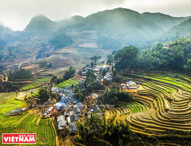
Besides the magnificent Dong Van Karst Plateau, Ha Giang Province has been known for its terraced rice fields, mostly in Hoang Su Phi District. It is said that the local terraced rice fields were built three to four centuries ago, mostly in the communes of Ban Luoc, San Sa Ho, Ban Phung, Ho Thau, Nam Ty and Thong Nguyen. They are among the country’s most popular beautiful spots and have been recognised as one of the national intangible heritages.
Every year, in late September and early October, the terraced rice fields in Hoang Su Phi become golden due to ripening paddies. The rice fields run around the mountain slopes, and ripened rice looks like golden carpets covering the mountain slopes. In the fields, ethnic Mong people are harvesting their rice. The scenery is so peaceful and romantic.
Meanwhile, in May and June, it is time to fill the terraced fields with water. The fields are sparkling, like a huge mirror shining with clouds and the sky reflected in it. The scenery is then extremely fanciful that seems to keep visitors staying longer.
With its advantages, in recent years Ha Giang has paid great attention to develop different forms of tours to attract more tourists to the province. A Village for Communal Culture and Tourism was built, which focused in developing homestay tours, and to date there are 29 such villages operating throughout the province while another 17 villages are under construction. These villages are mostly managed by the ethnic groups of Mong, Dao, Tay and Pa Then.
“Ha Giang leaders have set a target to develop tourism as a spearhead by 2020, which is expected to attract 1.5 million visitors, and by 2030 tourism will become a spearhead economy,” said Tran Duc Quy, Vice Chairman of Ha Giang Province People’s Committee.
To reach the goal, prime investment has been allocated to develop a tourism infrastructure in Dong Van Global Karst Geo-Park and Hoang Su Phi terraced rice fields. In addition, tourist trips are diversified, including Eco-tours, cultural, historical, geological, and religious tours, and convalescence tours. Such tours help promote local tourism and connecting tours among localities nationwide and also with those abroad, including those from Yunnan of China.
With its strong points and advantages, the Ha Giang tourism sector is expected to further develop in the very near future, making the province become one among the country’s key localities in the northwest having strong tourism development due to its unique tourist attractions.
Story: Hoang Quang Ha & Minh Tam
Photos: Hoang Quang Ha, Tat Son, Viet Cuong,Pham Lu,
Truong Tuan Giang & VNP’s files
The region embraces many historical relics and landscapes, such as the Heaven Gate, the Quan Ba double mountains in Quan Ba District; the Mong King’s Vuong Palace, the Lung Cu National Flag Pole in Dong Van District; the Ma Pi Leng Pass in Meo Vac District; the Fairy Fall, the Windy Pass and the Nam Dan ancient stone ground in Xin Man District and the Quang Ngan mineral spring in Vi Xuyen District. They attract many visitors to come for fun or for research.
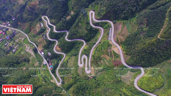 The Bac Sum Slope with winding mountain roads in Dong Van District. Photo: Hoang Quang Ha/VNP 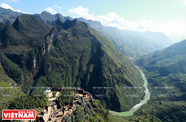 The Ma Pi Leng Pass at 1,600-1,800m above sea level is one of “four great passes in the north”. Photo: Hoang Quang Ha/VNP 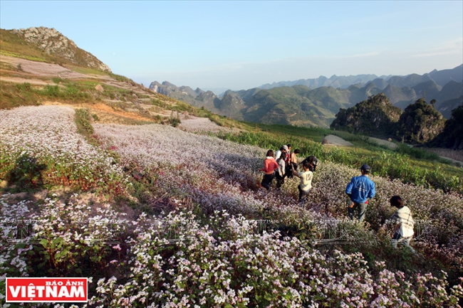 Tourists contemplate the beauty of violet buckwheat flower fields growing on rocky slopes in Dong Van District, Ha Giang Province. Photo: Tat Son/VNP 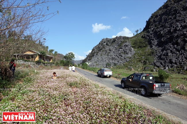 The traffic system on the karst plateau has been completed, facilitating the transport of tourists to Ha Giang. Photo: Tat Son/VNP |
| According to statistics from Ha Giang Department of Culture, Sports and Tourism, the number of tourists to Ha Giang Province has increased on an average of over 20 percent annually. In 2016, about 800,000 visitors came to Ha Giang, an increase of 5 percent over the same period the year before. Total turnover from tourism reached 800 billion dong. |
In 2012, the terraced rice fields in Hoang Su Phi District were listed among Vietnam’s national relics, and later in 2015 it became a national intangible cultural heritage. With its natural resources, Ha Giang Province obviously has many tourist sites of significant value.
Visitors to Ha Giang will be immersed in an atmosphere of wild and magnificent beauty with ranges of rugged rocky mountains stretching far beyond the eye, the terraced rice fields looking like paintings which are shining with a golden colour during harvest time, or sparkling in water during field-watering time. Amid the up and down mountainous slopes are grounds of beautiful violet buckwheat flowers. Here and there are houses-on-stilts of the local ethnic residents resting so peacefully with cooking smoke from the kitchens covering the dark green mountains in the later afternoon.
Visiting the rocky mountainous region
The Dong Van Karst Plateau is located at the height of 1,000-1,600m above sea level, covering the four districts of Quan Ba, Yen Minh, Dong Van and MeoVac with a total area of over 2,300km2. According to researchers, the locality is one among the country’s special karst mountain regions, which holds historical imprints of the earth crust’s evolution lasting for millions of years.
To fully enjoy the magnificent beauty of Dong Van Karst Plateau, visitors should take a trip by bus from Ha Giang along National Highway 4C for about 40km before they arrive in Quan Ba District. They would continue their trip upward to Yen Minh, Dong Van and Meo Vac districts. The total distance will be more than 150km, through winding mountainous paths full of challenges, but very exciting.
Along the way, visitors can contemplate the beauty of mountain ranges, one after another, with sharp rugged rocks pointing to the blue sky. They will discover many fascinating natural beautiful spots, including the Quan Ba Heaven Gate, which is 1,500m above sea level; the Can Ty Pass, which winds around mountain slopes, and especially the Ma Pi Leng Pass, considered one of the top-four high passes in Vietnam’s northwest region. Vast forests of pine trees whistling in the wind will please both eyes and ears.
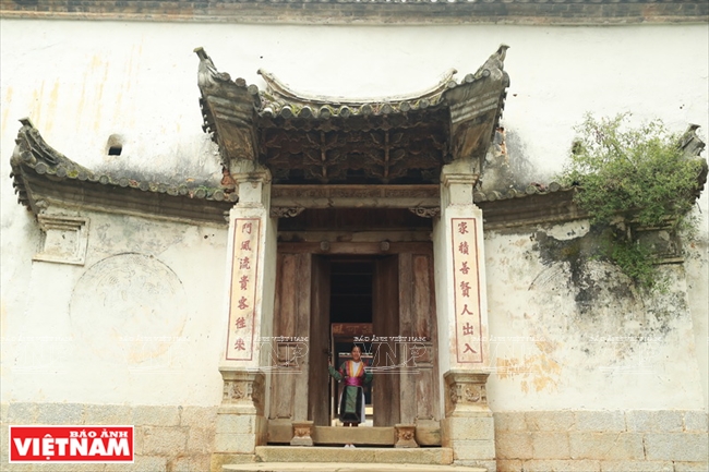 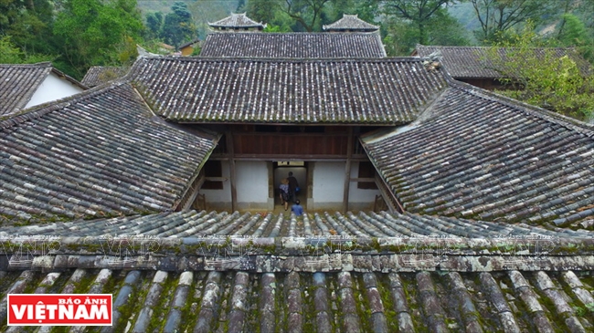 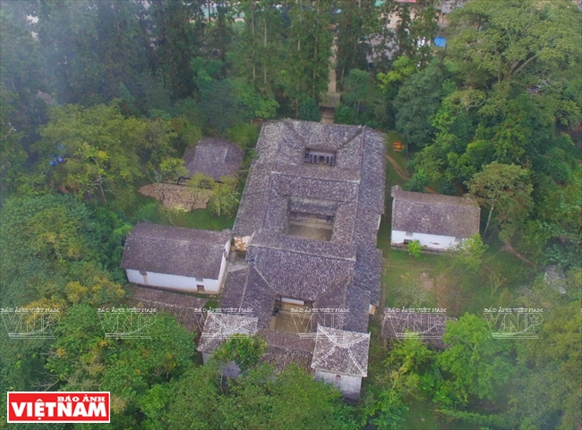 The Mong King’s Vuong Palace is located in Sa Phin Commune, Dong Van District. It was built on a total area of 1,120m2 with a united structure of three-layers. Photo: Hoang Quang Ha/VNP  Mong people cultivate on rugged rocks on Dong Van Karst Plateau Geopark. Photo: VNP’s file 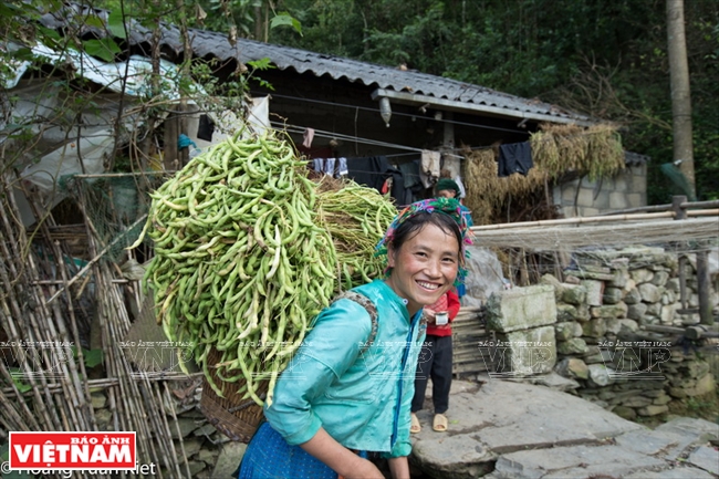 A Mong woman carries soya beans on her back from the terraced field to her house. Photo: Hoang Quang Ha/VNP 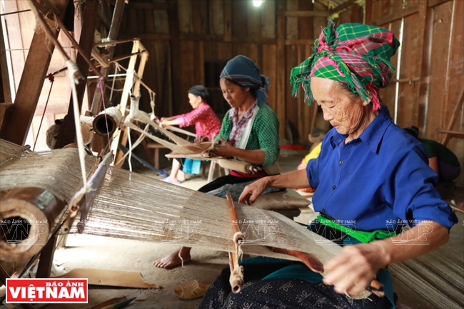 Mong artisan Giang Thi Co is weaving linen using the traditional method in Lung Tam Commune, Quan Ba District, Ha Giang Province. Photo: Hoang Quang Ha/VNP 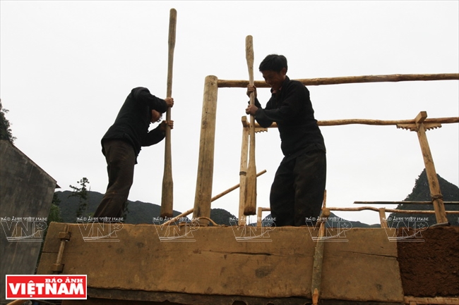 Mong people in Dong Van District use wood pestles and boards when building their Trinh tuong houses. Photo: Hoang Quang Ha/VNP 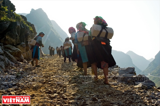 Mong women transport bricks to their hamlet to build new houses in Dong Van District. Photo: Viet Cuong/VNP 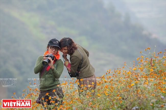 Tourists are fascinated by the fields of flowers in bloom on the karst plateau. Photo: Viet Cuong/VNP |
| Some villages for communal culture and tourism in Ha Giang Province: the Upper Lung Cam (in Sung La Commune, Dong Van District); Lang Giang Hamlet (Thong Nguyen Commune, Hoang Su Phi District); Ban Lan Hamlet (Yen Phu Commune, Bac Me District); Nam Dam Hamlet (Quan Ba Commune, Quan Ba District); Tha and Tien Thang Hamlets (Ha Giang City); Khuoi Lac Hamlet (Vi Xuyen District); Nam An Hamlet (Bac Quang District) and My Bac Hamlet (Quang Binh District). |
Beautiful all year round, however the Dong Van Karst Plateau shows off its beauty during the season of light violet buckwheat flowers from October-November, mostly in the fields in Pho La, Sung La, Lung Tao and Ma Le. When spring comes, yellow mustard flowers are blooming on the mountain slopes, and pink peach blossoms beside the old mossy house roofs. Their unique and magic beauty fascinate any visitors to the region.
In addition, visitors will have a chance to stay in the old palace of the former Mong King, which has been preserved through many historical ups and downs. Their car will drive on a road, named “A Road of Happiness”, built by young ethnic people, before they arrive at the Lung Cu Flag Pole, on its top the national flag flying high in the wind. The traditional culture and lifestyle of the local ethnic highlanders also attract many visitors, particularly researchers.
The life in the north pole area
Besides the magnificent Dong Van Karst Plateau, Ha Giang Province has been known for its terraced rice fields, mostly in Hoang Su Phi District. It is said that the local terraced rice fields were built three to four centuries ago, mostly in the communes of Ban Luoc, San Sa Ho, Ban Phung, Ho Thau, Nam Ty and Thong Nguyen. They are among the country’s most popular beautiful spots and have been recognised as one of the national intangible heritages.
Every year, in late September and early October, the terraced rice fields in Hoang Su Phi become golden due to ripening paddies. The rice fields run around the mountain slopes, and ripened rice looks like golden carpets covering the mountain slopes. In the fields, ethnic Mong people are harvesting their rice. The scenery is so peaceful and romantic.
 Ha Giang has strengths to develop home-stay tours in hamlets that provides tourists a chance to discover unique customs, cultural features and the lives of ethnic groups, including the Mong, Dao, Tay and Pa Then. Photo: Truong Tuan Giang 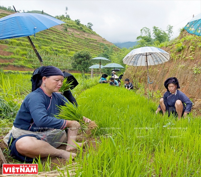 Mong people prepare rice seedlings for a new rice transplanting season on the terraced fields. Photo: Pham Lu 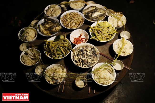 A tray of food and a ceremony to offer the Rice Genie of the Dao people group in Hoang Su Phi District. Photo: Hoang Quang Ha/VNP 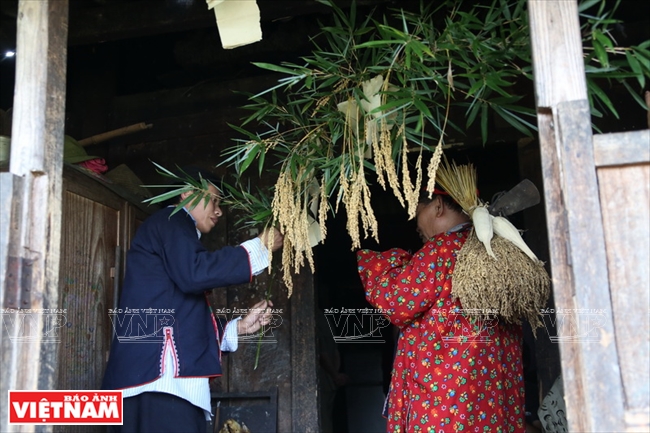 A ceremony to offer the Rice Genie of the Dao people group in Hoang Su Phi District. Photo: Hoang Quang Ha/VNP 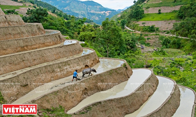 The terraced fields in Hoang Su Phi during the watering season. Photo: Pham Lu 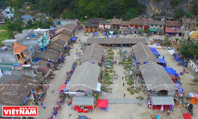 An ancient town in Dong Van. Photo: Hoang Quang Ha/VNP 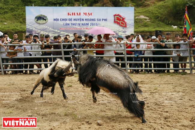 The goat fighting festival is held annually in Hoang Su Phi District. Photo: Hoang Quang Ha/VNP 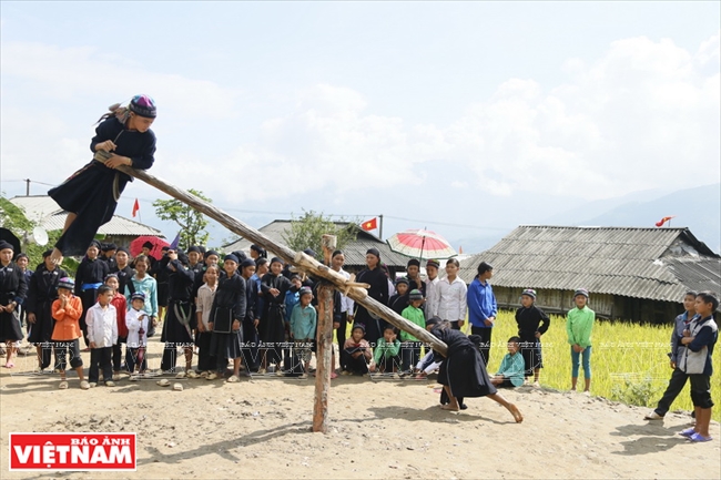 A traditional game of La Chi children in Ban Phung Commune, Hoang Su Phi District. Photo: Hoang Quang Ha/VNP 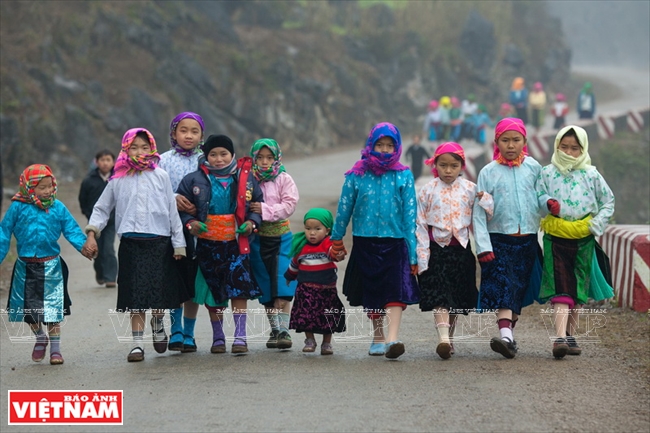 Mong children in their new traditional costumes take a walk on Ma Pi Leng Pass during Tet holidays. Photo: Viet Cuong/VNP |
Meanwhile, in May and June, it is time to fill the terraced fields with water. The fields are sparkling, like a huge mirror shining with clouds and the sky reflected in it. The scenery is then extremely fanciful that seems to keep visitors staying longer.
With its advantages, in recent years Ha Giang has paid great attention to develop different forms of tours to attract more tourists to the province. A Village for Communal Culture and Tourism was built, which focused in developing homestay tours, and to date there are 29 such villages operating throughout the province while another 17 villages are under construction. These villages are mostly managed by the ethnic groups of Mong, Dao, Tay and Pa Then.
“Ha Giang leaders have set a target to develop tourism as a spearhead by 2020, which is expected to attract 1.5 million visitors, and by 2030 tourism will become a spearhead economy,” said Tran Duc Quy, Vice Chairman of Ha Giang Province People’s Committee.
To reach the goal, prime investment has been allocated to develop a tourism infrastructure in Dong Van Global Karst Geo-Park and Hoang Su Phi terraced rice fields. In addition, tourist trips are diversified, including Eco-tours, cultural, historical, geological, and religious tours, and convalescence tours. Such tours help promote local tourism and connecting tours among localities nationwide and also with those abroad, including those from Yunnan of China.
With its strong points and advantages, the Ha Giang tourism sector is expected to further develop in the very near future, making the province become one among the country’s key localities in the northwest having strong tourism development due to its unique tourist attractions.
|
(Source: the Vietnam’s Committee on Ethnic Minority Affairs) |
Story: Hoang Quang Ha & Minh Tam
Photos: Hoang Quang Ha, Tat Son, Viet Cuong,Pham Lu,
Truong Tuan Giang & VNP’s files